Yellowstone National Park is one of the most geologically complex and scientifically revealing regions on Earth. Beneath its forests and rivers lies a volcanic system shaped by deep mantle forces, continental-scale eruptions, and transformative landscapes millions of years in the making. Yet the modern national park is only the latest chapter in a story that begins deep within the planet, long before there was a Yellowstone Plateau, much less a national treasure.
Over the course of this four-part series, we will explore how the forces that created Yellowstone reshaped the Pacific Northwest, carved river valleys across Idaho, built fossil-rich environments across the central United States, and eventually led to the political and cultural movements that preserved Yellowstone as the world’s first national park. This first post provides an overview of what is to come.
A Mantle Plume, Flood Basalts, and the Path to Yellowstone
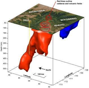
The story begins far below the crust, with a powerful mantle plume that rose toward the surface beneath what is now the Pacific Northwest. During the Miocene epoch roughly 17 million years ago, this plume produced enormous sheets of lava known as flood basalts, covering large portions of present-day Washington, Oregon, and Idaho. These events formed the Columbia River Basalt Group, one of the largest continental basalt provinces on Earth, and helped shape the early courses of the Columbia and Snake Rivers.
As the North American Plate drifted over the plume, volcanic centers migrated eastward across what is now southern Idaho, leaving behind a chain of calderas and lava fields stretching toward the modern Yellowstone Plateau. This corridor, known as the Snake River Plain, marks the path of successive supereruptions long before the current Yellowstone system developed. In the coming post, we will examine how these volcanic events formed the basalt plateaus of Washington, altered major river systems across the region, and carved a geological path toward Yellowstone itself.
How Eruptions Built the Modern Landscape and Preserved Ancient Life
In the second post, we will explore how repeated volcanic eruptions shaped not just the Yellowstone Plateau but a vast area reaching far beyond the current caldera. Successive eruptions over hundreds of thousands of years created volcanic plateaus, rhyolite domes, ash-flow tuffs, and hydrothermal systems that define the modern park. Features such as the Hayden Valley, the Absaroka Range, and the broad forests of lodgepole pine owe their origins to these explosive cycles.
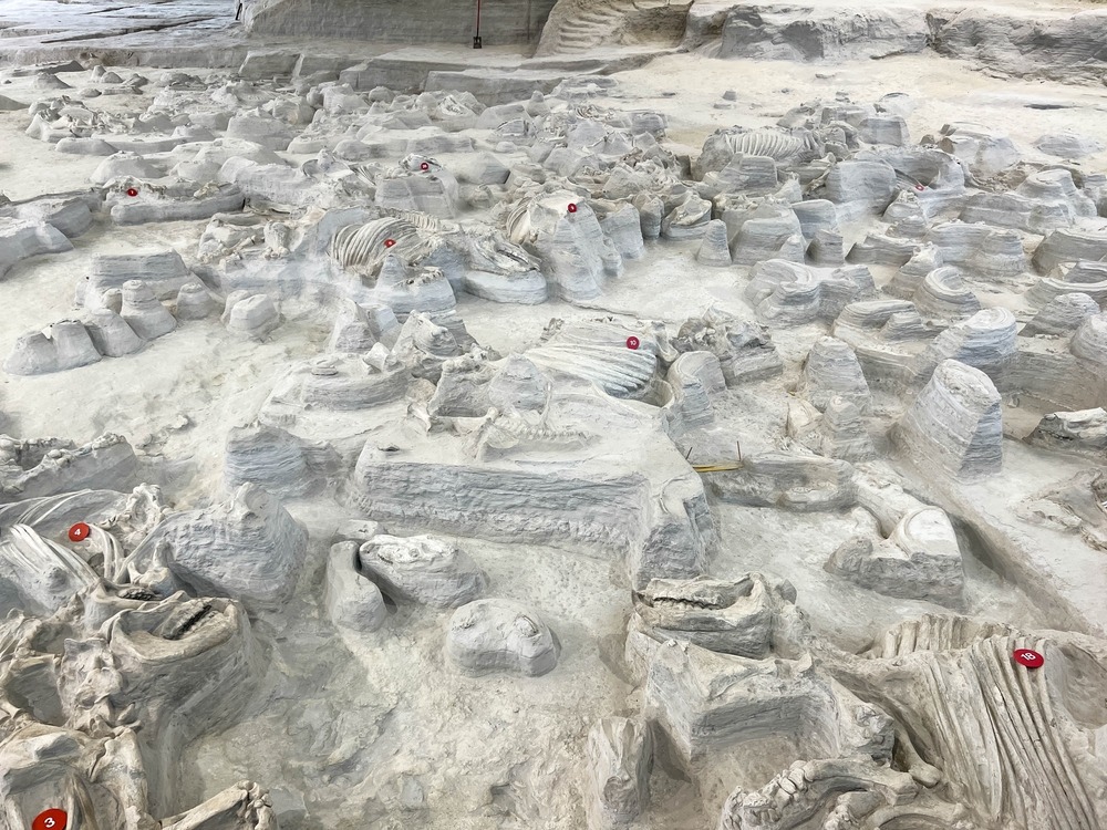
Importantly, Yellowstone’s eruptions also dispersed volcanic ash across thousands of miles of the continent. This ash helped preserve rich fossil beds—including the astonishing Ashfall Fossil Beds of Antelope County, Nebraska—where entire assemblages of Miocene animals were entombed in fine layers of volcanic ash. Across Wyoming, Idaho, and Nebraska, these deposits have allowed paleontologists to study ancient environments and ecosystems with extraordinary detail. The second post will trace how Yellowstone’s eruptive history shaped landscapes, ecosystems, and fossil records across the interior West.
From Frontier Legend to National Treasure
The final part of the geological story leads into the human history of Yellowstone. Long before scientists studied the caldera, Indigenous peoples understood the region as a place of powerful forces, sacred landscapes, and abundant resources. European-American explorers of the nineteenth century returned with tales of geysers, boiling springs, painted terraces, and deep canyons—stories that sounded mythical to many back home.
After geological surveys confirmed the region’s wonders, debates arose over how to treat the land: should it be exploited for resources or preserved for public benefit? Influential figures and conservation advocates argued for protection, leading to the creation of Yellowstone National Park in 1872, the first of its kind in the world. Later, President Theodore Roosevelt would champion the idea that America’s natural heritage should be safeguarded rather than diminished by private interests.
In the years immediately preceding the park’s creation, a number of individuals played critical roles in advocating for federal protection. Members of the Hayden Geological Survey—including Ferdinand V. Hayden himself—provided influential scientific reports, while artists and photographers such as Thomas Moran and William Henry Jackson supplied the imagery that captured the imagination of Congress and the American public. Politicians and conservation-minded thinkers worked to frame Yellowstone as a national treasure rather than a resource to be privatized. Their combined efforts contributed to the passage of the Yellowstone National Park Protection Act, signed by President Ulysses S. Grant on March 1, 1872, establishing Yellowstone as the world’s first national park.
A Mantle Plume, Flood Basalts, and the Path to Yellowstone
The geological story of Yellowstone begins long before the famous geyser basins formed, and far from the modern borders of the park. It starts deep within the planet, with a mantle plume rising from the boundary between Earth’s core and mantle. This plume supplied heat and magma to the base of the continental crust, initiating one of the most extraordinary volcanic episodes in North America’s history. From this hotspot came immense lava floods, reshaped river systems, and a volcanic trail that stretches from the Pacific Northwest to northwest Wyoming. Understanding Yellowstone requires beginning in Washington, Oregon, and Idaho—regions where the hotspot first made its presence known.
The Mantle Plume Beneath the Northwest
A mantle plume is a column of unusually hot rock rising through the mantle. Unlike typical plate-boundary volcanism, plumes can form volcanoes in the middle of tectonic plates. The Yellowstone hotspot plume rises beneath the North American Plate and has been doing so for tens of millions of years. Around 17 million years ago, when the plume head reached the lithosphere, it triggered a phase of enormous basalt eruptions during the Miocene epoch. These were not single volcanic events, but sustained eruptions that poured out vast quantities of low-viscosity lava.
The Columbia River Flood Basalts and the Birth of a Volcanic Province
The initial activity of the Yellowstone hotspot produced the Columbia River Basalt Group, one of the largest continental flood basalt provinces in the world. Lava erupted from long fissures rather than centralized volcanoes, creating sheets of basalt hundreds of feet thick.
The flood basalts covered what is now:
Eastern Washington
Northeastern Oregon
Parts of Idaho and Western Montana
In total, these lava flows reached volumes measured in hundreds of thousands of cubic kilometers. The thick layers of cooled basalt now form the backbone of the Columbia Plateau. This event was catastrophic in scale and transformed ecosystems, river pathways, and regional topography.
How the Hotspot Altered the Columbia and Snake Rivers
The Columbia River and the Snake River systems are intimately connected to this volcanic past. The Columbia once drained a very different landscape before basalt flows rearranged drainage patterns. As lava flooded across the region, it:
Dammed ancient stream valleys
Redirected river courses
Forced new drainage routes across the growing basalt plateau
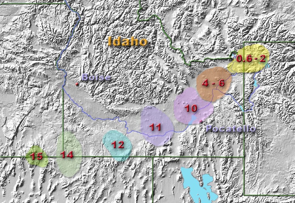
The Snake River, now a tributary to the Columbia, took shape within this volcanic framework. As the North American Plate continued to move southwest over the stationary hotspot, volcanism migrated eastward. This motion created a geologic footprint across southern Idaho, known today as the Snake River Plain.
The Snake River Plain: A Trail of Calderas
Below is a video production by geologist Shawn Willsey where he discusses the history of the Yellowstone hotspot and how it impacted the Pacific Northwest and the Snake River Plain:
The Snake River Plain is a sweeping arc of volcanic terrain extending from the Oregon–Idaho border to the modern Yellowstone Plateau. It marks the path of the hotspot as the continental plate drifted over it. Instead of basaltic fissure eruptions like those in Washington, volcanism along the Snake River Plain shifted toward explosive rhyolitic caldera-forming events.
Over millions of years, a series of supereruptions produced overlapping calderas across southern Idaho. Among them are the Bruneau-Jarbidge, Picabo, and Heise caldera complexes. Each represents a colossal event that emptied magma chambers and caused the land to collapse inward. These events occurred sequentially, leaving behind a chain of volcanic scars stretching toward what would eventually become Yellowstone.
Carving the Yellowstone Pathway
The movement of the hotspot beneath the continental crust shaped more than volcanic terrain. It affected elevation, drainage, and geomorphology. The Snake River Plain formed a lowered corridor through Idaho, bordered by highlands and mountain ranges. Erosion and river processes then exploited this weakness.
As a result:
The Snake River carved a broad valley across Idaho
Sediment transported from volcanic and glacial sources filled the growing plain
Lava flows periodically resurfaced the landscape
This geologic corridor guided not only the river but also future ecosystems, migration routes, and—much later—human travel and settlement patterns.
Arrival at Yellowstone
By roughly 2.1 million years ago, the center of hotspot activity had reached what is now northwest Wyoming. The modern Yellowstone volcanic system was born through a sequence of three major caldera-forming eruptions at approximately:
2.1 million years ago (Huckleberry Ridge Tuff)
1.3 million years ago (Mesa Falls Tuff)
640,000 years ago (Lava Creek Tuff)
These eruptions dwarf anything in recorded human history and represent the culmination of the hotspot’s eastward march across the continent. The volcanic depression left by the most recent of these—the Yellowstone Caldera—hosts the geyser basins, hydrothermal systems, and geothermal wonders that define the park today.
The stage was now set: the hotspot had journeyed from Washington to Wyoming, reshaping land, rivers, and ecosystems along the way. But the story does not end here, because those massive eruptions built landscapes far beyond the caldera itself. They also scattered ash across vast regions of North America, creating environments in which ancient life would be buried and preserved.
Eruptive Cycles, Landscape Formation, and Fossil Preservation
The Yellowstone hotspot produced a series of volcanic cycles that reshaped the terrain of the American West. These eruptive events built high plateaus, carved broad valleys, altered river systems, and spread ash across the central United States. As activity moved beneath northwest Wyoming, the hotspot generated three major caldera-forming eruptions over the last 2.1 million years, each leaving a geological signature both inside and far beyond Yellowstone National Park. In the video below, GeoGirl (AKA, Dr Rachel Phillips) gives more details on the geological history of Yellowstone).
The Three Major Eruptive Cycles of the Yellowstone Plateau
Yellowstone’s volcanic system is defined by three major supereruptions that formed overlapping calderas. These eruptions are recognized by widespread ash deposits called tuffs, which provide a chronological framework for how the landscape evolved.
Huckleberry Ridge Tuff, approximately 2.1 million years ago
Mesa Falls Tuff, approximately 1.3 million years ago
Lava Creek Tuff, approximately 640,000 years ago
Each eruption expelled thousands of cubic kilometers of magma, collapsed large areas of land into calderas, and deposited vast sheets of pyroclastic material. These eruptions are among the largest known in Earth’s geologic record.
Building the Modern Yellowstone Landscape
After the major caldera events, Yellowstone entered a period marked by smaller eruptive pulses, lava flows, and hydrothermal activity. Much of the park’s present-day terrain reflects these later phases rather than a single catastrophic event.
Several major landscape features formed through these volcanic processes:
The Yellowstone Plateau formed from repeated rhyolite lava flows
Rhyolitic domes and lava flows reshaped the uplands of the park
The Grand Canyon of the Yellowstone was cut into altered volcanic rocks by river erosion
Hayden Valley and similar depressions trace older caldera boundaries
Although the central plateau sits above the active caldera, volcanic influences extend far outside its rim. Mountain ranges such as the Absaroka Range reflect earlier volcanic arcs that predate the hotspot and help define the modern skyline of Yellowstone.
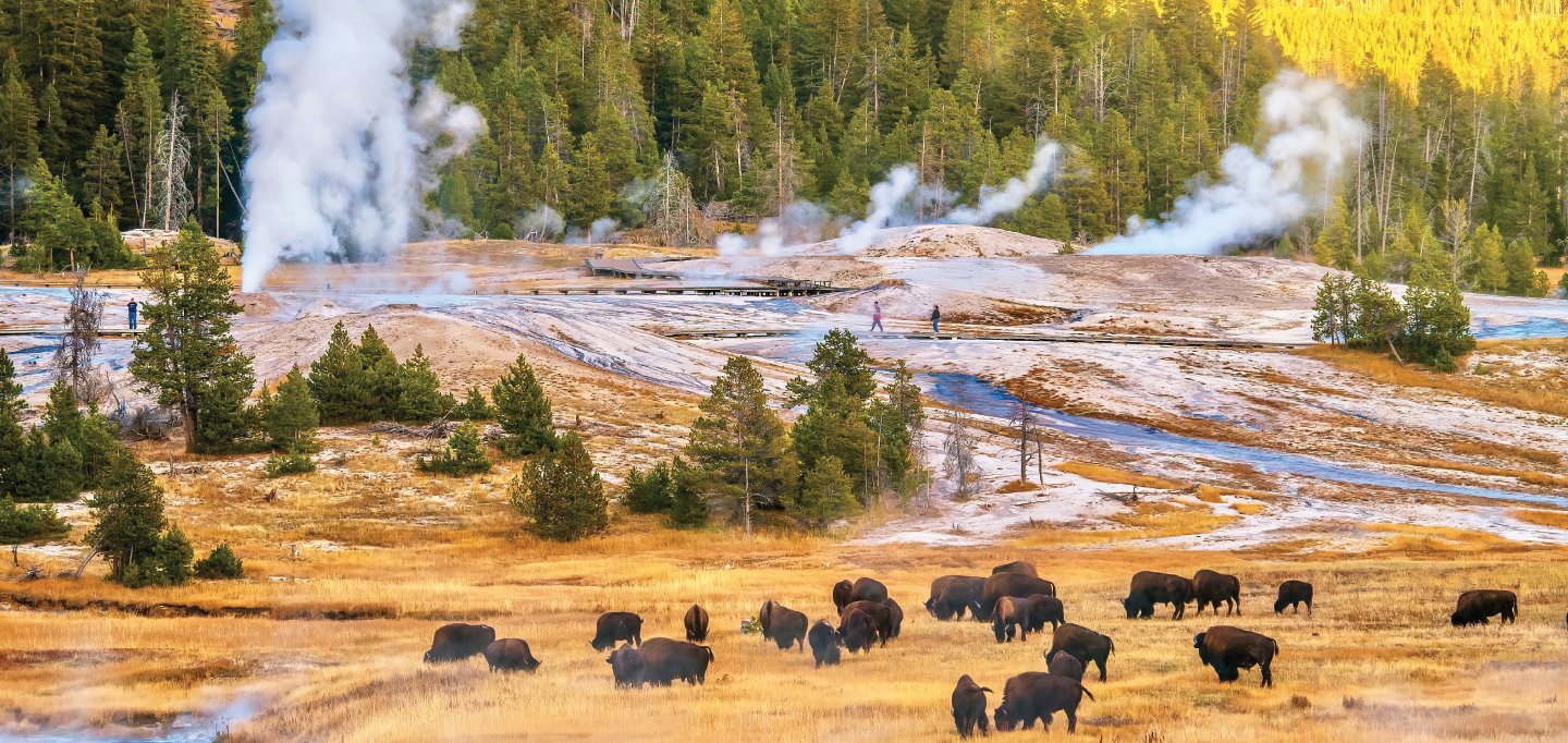
Hydrothermal Systems and Ongoing Volcanic Heat
Heat from the hotspot continues to rise beneath Yellowstone, powering one of the world’s most extensive hydrothermal systems. This interaction between heat and groundwater produces geysers, hot springs, fumaroles, and mudpots.
Hydrothermal activity affects surface landscapes in several ways:
Chemical alteration produces clays and silicas that influence erosion and coloration
Siliceous sinter creates terraces, mounds, and cones around spring vents
Continuous deposition and dissolution reshape thermal basins in short geologic timescales
These features show that Yellowstone remains an active volcanic environment even without large eruptions.
Ash Dispersal Across the Continent
The influence of Yellowstone’s eruptions extends across North America. Supereruptions ejected ash high into the atmosphere, allowing wind to transport fine material across thousands of miles. Ash deposits in states as distant as Nebraska and Kansas provide evidence of these massive volcanic events.
The consequences of ash dispersal include:
Formation of thick ash layers across the Great Plains
Alteration of soil composition and regional ecosystems
Rapid burial of biological material suitable for fossilization
These ashfalls set the stage for exceptional paleontological preservation.
Fossil Preservation from Wyoming to Nebraska
Fine volcanic ash from Yellowstone eruptions preserved fossil sites far beyond the park. Rapid burial allowed skeletal remains, plant matter, and even traces of respiratory distress to fossilize in place.
Notable sites influenced by Yellowstone ash include:
Fossiliferous volcanic sediments across western Wyoming
The Ashfall Fossil Beds of Antelope County, Nebraska, preserving Miocene rhinos, camels, and horses
Paleosols and sediment horizons across the Great Plains capturing ancient ecological communities
The Ashfall site is especially significant because it preserves animals in natural positions with articulated skeletons, offering rare insight into prehistoric behavior and ecosystems.
Yellowstone’s Influence Beyond the Caldera
Yellowstone is not an isolated phenomenon. Its geologic effects:
Shaped river systems in the Pacific Northwest
Built volcanic plateaus across Idaho and Wyoming
Deposited ash across the Great Plains
Created fossil-rich environments in multiple states
From the Columbia River Basalts in Washington to fossil beds in Nebraska, the Yellowstone hotspot has left a continental-scale imprint on landscapes and life.
In the next installment of this series, we will explore the human history of Yellowstone, including Indigenous relationships with the land, nineteenth-century expeditions, and the political movement that led to the establishment of the world’s first national park.
Early Exploration, Scientific Discovery, and the Road to National Park Status
Yellowstone’s geological story transitions into human history long before the arrival of European-American expeditions. Indigenous peoples interacted with the region for thousands of years, viewing its hydrothermal features, rivers, and wildlife habitats as parts of a culturally meaningful landscape. The arrival of nineteenth-century explorers introduced Yellowstone’s geothermal wonders to a broader audience, setting the stage for political and cultural debates over how the land should be treated. These developments eventually contributed to the creation of Yellowstone National Park in 1872.
Indigenous Presence and Knowledge
Archaeological and ethnographic evidence shows that Indigenous peoples have been present in the Yellowstone region for at least 10,000 to 12,000 years. Tribes used the area for hunting, plant gathering, and obsidian tool production. Obsidian from Obsidian Cliff has been found across North America, confirming that trade networks carried Yellowstone materials far beyond the region.
Indigenous cultural perspectives varied but often framed Yellowstone’s geothermal features as spiritually significant or powerful. Oral traditions, place names, and seasonal use patterns demonstrate a long-standing familiarity with the land’s unique qualities.
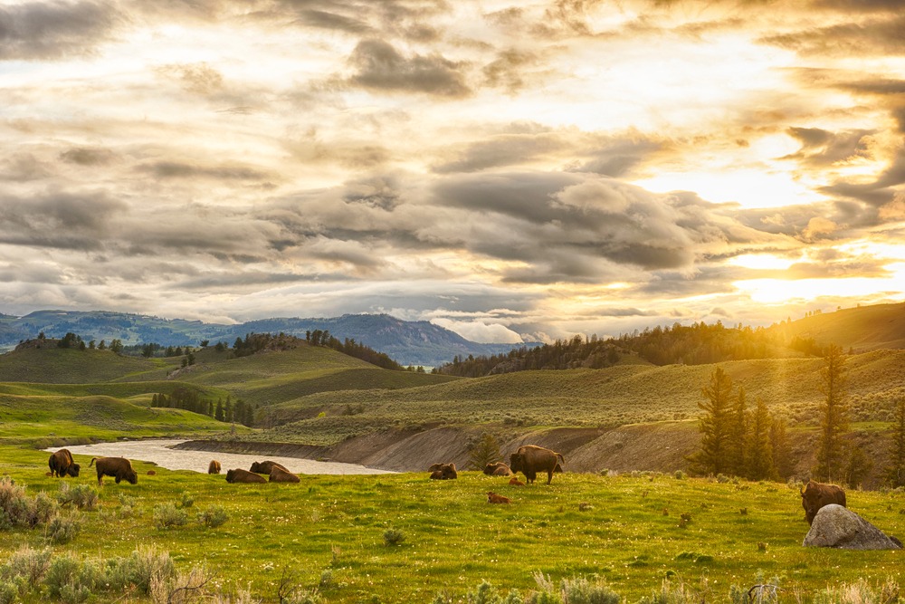
Hunting grounds supported bison, elk, and deer populations
Hot springs and geysers were integrated into cultural narratives
Obsidian served as a valuable trade and tool-making material
The continuity of Indigenous presence challenges later narratives that depicted Yellowstone as an undiscovered wilderness.
Nineteenth-Century Exploration and Reporting
Yellowstone remained largely unknown to Euro-American audiences until the nineteenth century. Early trappers and mountain men reported unusual geothermal activity, but their accounts were frequently dismissed as exaggerations or tall tales.
This began to change with organized expeditions:
The Cook-Folsom Expedition of 1869 recorded observations of geysers, thermal basins, and canyons
The Washburn-Langford-Doane Expedition of 1870 provided more detailed documentation and mapping
Military escorts and survey teams introduced scientific rigor to regional descriptions
These expeditions brought back descriptions of boiling springs, erupting geysers, expansive waterfalls, and vividly colored terraces. Their reports sparked public curiosity and renewed pressure for further scientific evaluation.
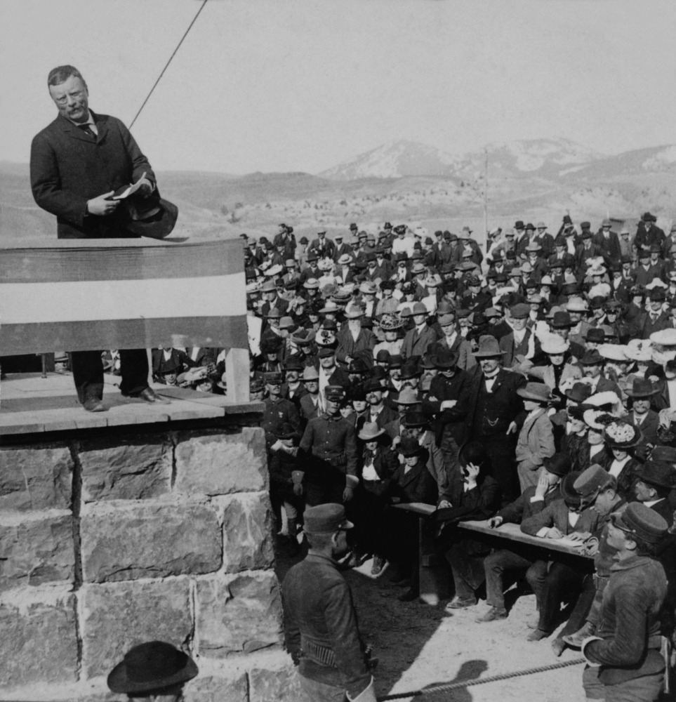
The Hayden Geological Survey and Scientific Validation
In 1871, the Hayden Geological Survey, led by Ferdinand V. Hayden of the U.S. Geological and Geographical Survey of the Territories, became the first federally funded scientific expedition to Yellowstone. The survey included geologists, botanists, zoologists, cartographers, photographers, and artists.
Key contributions of the Hayden Survey included:
Geological descriptions of volcanic and hydrothermal features
Photographic documentation by William Henry Jackson
Landscape paintings by Thomas Moran
Detailed maps and scientific inventories of the region
The images and artwork produced by the survey provided visual proof of Yellowstone’s wonders. Combined with Hayden’s written reports, these materials circulated widely and helped build congressional support for protecting the area from commercial exploitation.
The Path to National Park Protection
As information spread, discussions emerged about how to treat Yellowstone’s remarkable landscapes. The prevailing concern was that private interests might seek to monetize geothermal features, timber resources, or mineral deposits. Advocates argued that Yellowstone should instead be preserved for public benefit and scientific study.
The Yellowstone National Park Protection Act was drafted in response to these concerns. Influential supporters included members of the Hayden Survey, as well as artists, photographers, scientists, and policymakers who saw value in permanent federal oversight. Their efforts stressed that Yellowstone’s features were unique and that no similar landscape existed elsewhere within the United States.
The Yellowstone National Park Protection Act of 1872
On March 1, 1872, President Ulysses S. Grant signed the Yellowstone National Park Protection Act into law, establishing Yellowstone as the first national park in the world. The Act withdrew the land from settlement, homesteading, and commercial resource extraction, placing it under federal supervision.
The law stated that Yellowstone National Park should be preserved for the benefit and enjoyment of the people, establishing a model for future conservation legislation. Yellowstone’s designation marked a turning point in American environmental policy and inspired later park creation both domestically and internationally.
Roosevelt and the Expansion of Conservation Ideals
Decades after the park’s establishment, President Theodore Roosevelt played a key role in advancing conservation principles across the United States. Roosevelt viewed public lands as a national inheritance that should not be exhausted for private gain. During his presidency, he worked to create additional national parks, monuments, and refuges, expanding the idea that natural landscapes could serve educational, ecological, and recreational purposes.
Although Roosevelt did not sign the original Yellowstone legislation, his policies reinforced the idea that landscapes like Yellowstone should be protected for future generations rather than developed purely for economic profit.
With Yellowstone formally established and conservation ideals taking root, the final installment of this series will examine how these geological and historical developments shaped modern perceptions of national parks, influenced global conservation, and left a lasting legacy on American environmental thought.
Yellowstone’s Legacy and the Birth of a Global Conservation Ethic
With Yellowstone established as a national park in 1872, the idea of preserving natural landscapes for their ecological, scientific, and cultural value began to expand. Yellowstone’s creation did not arise from a single moment, but from the convergence of geological wonder, Indigenous history, scientific advocacy, political action, and shifting attitudes about land stewardship. These strands merged into a new philosophy: that certain places should remain protected for the benefit of all people rather than be claimed, divided, or exploited.
The Influence of Yellowstone on American Conservation
Yellowstone’s designation helped change the nation’s relationship with its own landscapes. In the nineteenth century, the dominant pattern was to survey, sell, and settle public lands. The establishment of Yellowstone introduced an alternative model based on preservation and shared inheritance. This influenced public dialogue, national policy, and the emerging roles of government agencies.
Key developments influenced by Yellowstone included:
The creation of additional national parks such as Yosemite and Sequoia
The establishment of national forest reserves to protect watersheds and timberlands
The expansion of national monuments under the Antiquities Act of 1906
The formation of the National Park Service in 1916 to administer protected lands
These policies gradually built infrastructure for a durable conservation system, using Yellowstone as a philosophical and administrative template.
Yellowstone as a Model for Protected Areas
Yellowstone’s significance extends beyond its borders because it served as the first example of a category that did not previously exist. The idea of a national park was not widely established anywhere when the Yellowstone National Park Protection Act was signed. The park’s creation demonstrated that governments could withhold land from private claims and preserve it through legal designation.
This model influenced protected area frameworks worldwide. Over the following decades, countries across multiple continents adopted similar approaches, creating parks, reserves, and preserves to safeguard ecological and geological heritage.
Today, Yellowstone is recognized as a pioneering example in the international protected area system and continues to serve as a point of reference for conservation planning, environmental education, and ecological research.
Scientific Research and Ecological Understanding
Yellowstone’s volcanic and ecological systems have made it an important site for scientific study. Its geology provides a laboratory for understanding volcanic hotspots, caldera systems, hydrothermal activity, and continental-scale ash dispersal. Its ecosystems offer opportunities to study predator-prey dynamics, habitat restoration, and species reintroduction.
Notable areas of research at Yellowstone include:
Volcanic monitoring and geothermal system analysis
Wolf reintroduction and trophic cascade effects
Wildfire ecology and forest succession
Thermophilic microbial communities in hot springs
These studies have broadened scientific knowledge in fields ranging from volcanology to microbiology, often producing insights that extend well beyond the park itself.
Cultural and Educational Impact
Yellowstone’s cultural impact has grown alongside its scientific importance. The park has become a symbol of wilderness and natural heritage within the American imagination. It attracts millions of visitors each year who seek experiences that cannot be replicated in urban environments or constructed landscapes.
Through museums, interpretive centers, educational programs, and public outreach, Yellowstone has become a platform for teaching about geology, ecology, conservation policies, and Indigenous histories. These efforts foster an understanding that protected areas serve cultural, recreational, and educational needs as well as scientific and ecological ones.
Yellowstone’s Enduring Legacy
Yellowstone’s origin story spans deep time and broad cultural horizons. It begins with a mantle plume that shaped continents and carved river valleys. It continues through cycles of volcanic eruptions that built plateaus, created calderas, and preserved fossil-rich ash beds across the interior West. It extends into human history through Indigenous knowledge, scientific expeditions, artistic documentation, and political advocacy. It culminates in a landmark act of preservation that transformed national policy and inspired global conservation movements.
As the world’s first national park, Yellowstone became more than a place; it became a precedent. It showed that societies could choose to protect landscapes rather than consume them, that natural wonders could belong to all people rather than to private interests, and that stewardship could serve both present and future generations. Its legacy endures in every national park, world heritage site, wildlife refuge, and protected landscape that followed.
The Yellowstone region remains dynamic, both geologically and culturally. Its geysers continue to erupt, its caldera continues to evolve, and its ecosystems continue to adapt. Just as importantly, its ideas continue to resonate, reminding us that the preservation of natural heritage is an ongoing responsibility and a shared human achievement.
Staying in one of only two Owner’s Penthouse Suites is the ultimate indulgence. Your home away from home is located at the bow of the yacht, on Deck 9, boasting the best views on board. With a private dining area that can comfortably seat up to eight guests, you’ll never want to leave.
For a once-in-a-lifetime cruising experience, combine the Owner’s Penthouse Suites with a Spa Suite to create a lavish Two-Bedroom Penthouse Suite – an incredible 2,637 sq ft of unsurpassed ultra-luxury and opulence.
Suite inclusions
Bedroom Suite (sofabed, reading chair, 60-inch UHDTV, fully-adjustable King Size Slumber Bed)
priority and guaranteed services and amenities (dining in specialty restaurants, shore excursions, discovery tours / helicopter, submarine, zodiacs, kayaks, e-bikes).
Eclipse Panorama Suites
These grand suites include a host of special features and services. Curl up in your lounge with a kindle e-book from your in-suite library and sip your favorite aperitif, personally delivered by your butler – all before enjoying an intimate dining experience, in the plush and private surroundings of your suite. Even from the comfort of your bedroom, you’ll never miss a photo opportunity – access the outside world through your drop-down balcony window, with the gentle touch of a button, and with your in-suite binoculars.
Each Panorama Suite offers 1185 ft2 / 110 m2 and the following complimentary services and amenities:
Suite inclusions
Bedroom Suite (sofabed, reading chair, 60-inch UHDTV, mirrored vanity / writing desk with chair)
Butler bar (Nespresso, specialty teas, bottled water / all replenished daily)
Step-out balcony (outdoor terrace furnished with 1 table and 2 chairs)
Dedicated butler service
complimentary (limited per day) laundry service
1-hour complimentary spa treatment (per cabin)
priority and guaranteed services and amenities (dining in specialty restaurants, shore excursions, discovery tours / helicopter, submarine, zodiacs, kayaks, e-bikes).
Spa Suites
Suite names and amenities are the same across both Scenic Eclipse and Scenic Eclipse II, however, both have been thoughtfully curated to suit the cruising experience of these ships.
Ranging in size from 495-540 ft2 / 46-50 m2, located on Deck 8 to 9, each suite includes:
Suite inclusions
King Size Slumber Bed, UHDTV, Bose sound system
mirrored vanity / writing desk with chair
walk-in wardrobe
steam shower, full-size spa bath, single vanity, separate toilet, luxury bath amenities
Lounge area (reading chair, 2-seat sofa, coffee table, mini bar / restocked daily)
Butler bar (Nespresso, specialty teas, bottled water / all replenished daily)
Step-out balcony (furnished with 1 table and 2 chairs)
Dedicated butler service
Complimentary (limited per day) laundry service
1-hour complimentary spa treatment (per cabin)
Verandah Suites
Deluxe Verandah and Verandah suites are with the same amenities, differing only by deck location.
Each Deluxe Verandah and Verandah Suite offers the following complimentary services and amenities:
Ranging in size from 345-365 ft2 / 32-34 m2, located on Deck 5 to 8, each suite includes:
Suite inclusions
Bedroom area (Luxury King Size Slumber Bed, 40-inch UHDTV)
walk-in wardrobe
bathroom (shower, single vanity, separate toilet, luxury bath amenities)
Lounge area (Bose sound system, reading chair, coffee table, 2-seat sofa, mirrored vanity / writing desk with chair)
Mini-bar (restocked daily)
Butler bar (Nespresso, specialty teas, bottled water / all replenished daily)
Step-out balcony (furnished with 1 table and 2 chairs)
Butler service
Grand Deluxe Verandah Suites
Admire your window to the world. These incredibly spacious and thoughtfully designed suites feature floor-to-ceiling sliding glass doors that open onto sprawling vistas, spectacular seascapes, and marvelous marine life. Your private verandah or terrace is the perfect place to unwind as a new world of wonder moves by.
Ranging in size from 344-366 sq ft, located on Deck 5 to 8, each suite includes:
Suite inclusions
A private verandah with in-suite binoculars for optimal viewing
Luxury king-size Scenic Slumber Bed
Separate sleeping zone and lounge area
En-suite bathroom with shower and vanity
Luxury bathroom amenities and Dyson hairdryer
Ambient lighting options
Personalized butler service
A full complimentary mini-bar stocked with wines, champagne, and spirits personalized to your preference, including illy coffee and specialty teas re-stocked daily
In-suite beverage and dining service
HDTV entertainment system and Bose® speakers
Advanced Heating, Ventilation, and Air-Conditioning system (HVAC) provides 100% fresh air
The highest sound insulation as per the marine class society Bureau Veritas
Our generously sized Grand Deluxe Verandah Suites are slightly larger than the Verandah Suites. Ranging in size from 409 to 430 sq ft, they are furnished with the finest ultra-luxury amenities, including a plush king-size bed, a pillow menu, a walk-in closet, and a lounge area to unwind in after a day of exploration.
Suite amenities are the same across both Scenic Eclipse and Scenic Eclipse II, however, both have been thoughtfully curated to suit the cruising experience of these ships.
Emerald Harmony Grand Balcony Suite
Owner’s One-Bedroom Suite
Only two Owner’s One-Bedroom Suites are available on Emerald Harmony, making them our most exclusive suites. Enjoy your own private terrace, complete with a spacious hot tub for ultimate indulgence, as well as an extra roomy lounge and bedroom.
Emerald Grand Balcony Suite
Grand Balcony Suite
These beautifully appointed suites host an indoor private balcony with drop-down windows, as well as a separate bedroom and lounge area, providing plenty of space to unwind and relax.
Emerald Harmony Panorama Balcony Suite
Emerald Panorama Balcony Suite
An indoor private balcony with open-air system is perfect for enjoying the ever-changing views. Benefit from your en-suite bathroom, complete with indulgent toiletries, and sleep soundly in your queen-size or twin hotel-style bed.
Emerald Harmony Stateroom (CAT D)
Emerald Stateroom | Riviera Deck
Our staterooms boast ample space in which to relax. Enjoy your time in your home-away-from-home, with everything you could possibly need, including porthole river views for seeing the picturesque landscape of Southeast Asia pass by.
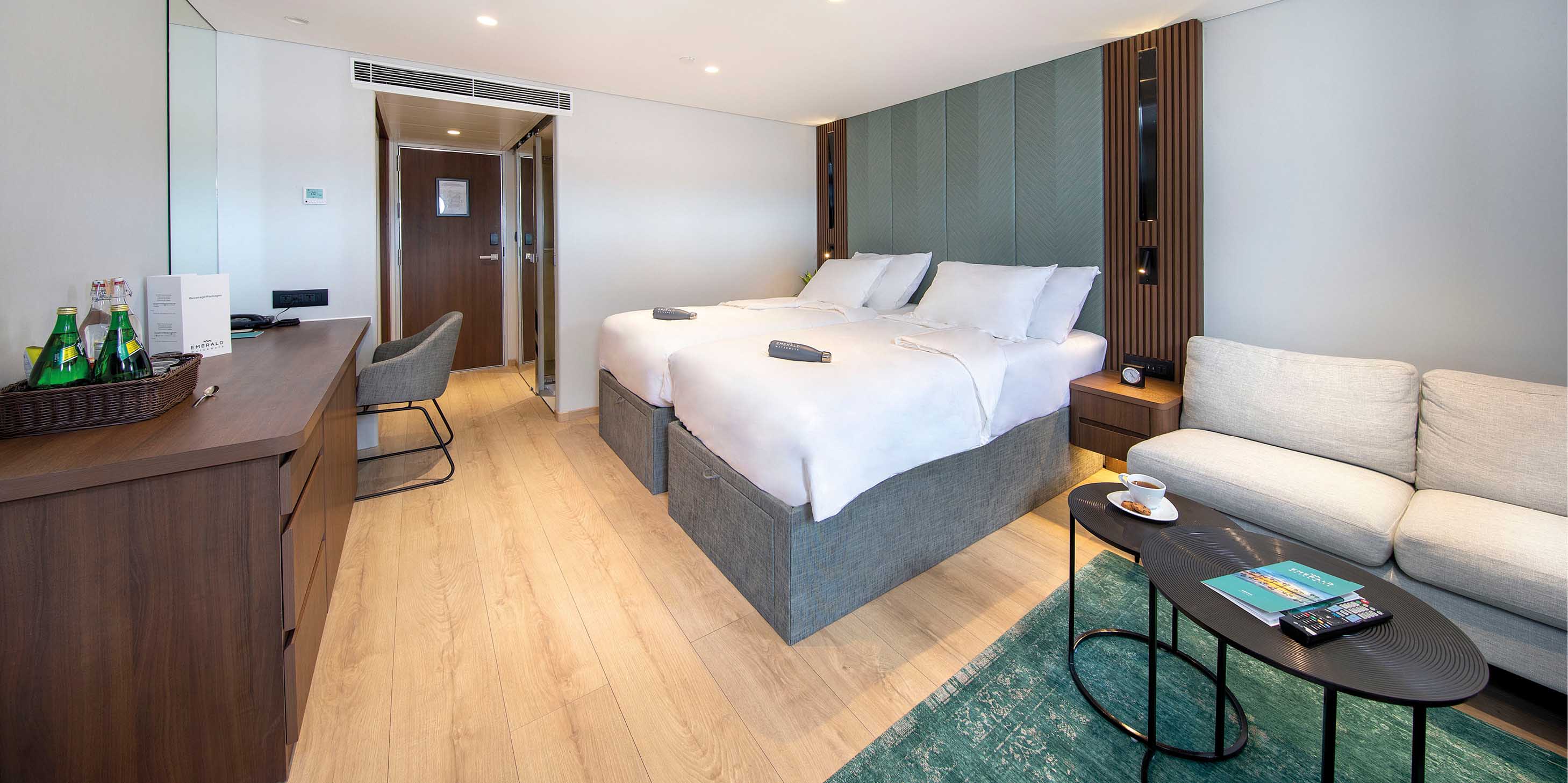
Deluxe Verandah Suite
32m² / 344ft²
Suite inclusions
Private Verandah
Luxury king size Scenic Slumber Bed
Separate sleep zone
Separate lounge area
En-suite bathroom with shower and vanity
Luxury bathroom amenities
Advanced Heating, Ventilation and Air-Conditioning system (HVAC) provides 100% fresh air
Butler service
Shoeshine service
Early morning tea/coffee service
In-suite beverage service
In-suite dining service
Full mini-bar re-stocked daily
Personalised butler bar featuring Illy coffee and specialty teas (replenished daily)
HDTV entertainment system
Oops! We could not locate your form.
Request a Quote
Request a quote Tours
Oops! We could not locate your form.
Request a Quote
Oops! We could not locate your form.
Request a Quote
Request a Quote
Oops! We could not locate your form.
Owner's One-Bedroom Suite (CAT SA)
Riverview Suite | Horizon Deck
Suite inclusions
Outdoor private balcony with open-air system
Separate bedroom and lounge area
Queen-size or twin hotel-style beds
Pillow menu
En-suite bathroom with shower, indulgent toiletries, hair dryer, on-board complimentary bathrobes and slippers
Walk-in wardrobe
Complimentary in-suite mini- bar, restocked daily with wine, beer and soft drinks
Complimentary Nespresso machine
Continental breakfast, pre-dinner canapés and after-dinner sweet treats served in your suite
Four items of laundry per day
Complimentary water, restocked daily
Complimentary Wi-Fi
Use of an iPad
Flat screen TV and infotainment system
Individual climate control
Personal safe
Umbrella
Telephone
Walking sticks
Gem Royal One-Bedroom Suite RP
Royal One-Bedroom Suite RP | Diamond Deck
Suite inclusions
Luxury queen size slumber bed
Scenic Sun Lounge
Marble bathrooms with upgraded bathroom amenities
Complimentary mini bar
Mac-mini infotainment system with complimentary movies on demand
Hairdryer, alarm clock, telephone, In room safe
International power sockets
Luxury bathrobe and slippers
Nordic walking sticks
Butler service
Shoeshine service
Early morning tea/coffee service
Unlimited complimentary laundry service
Daily delivery of personalised savoury and sweet canapes or fruit
Complimentary welcome bottle of Champagne (750ml)
Morning delivery of newspapers
Beverage and meal service in your private suite
Packing and unpacking your luggage
€200 per suite on board credit for use in the Wellness Centre
Private transfers in Europe*
Exclusive invitation to dine at Table La Rive
Priority dining reservations
Gem Royal Balcony Suite R
Royal Balcony Suite R | Diamond Deck
Suite inclusions
Luxury queen size slumber bed
Scenic Sun Lounge
Marble bathrooms with upgraded bathroom amenities
Complimentary mini bar
Mac-mini infotainment system with complimentary movies on demand
Hairdryer, alarm clock, telephone, In room safe
International power sockets
Luxury bathrobe and slippers
Nordic walking sticks
Butler service
Shoeshine service
Early morning tea/coffee service
Unlimited complimentary laundry service
Daily delivery of personalised savoury and sweet canapes or fruit
Complimentary welcome bottle of Champagne (750ml)
Morning delivery of newspapers
Beverage and meal service in your private suite
Packing and unpacking your luggage
€200 per suite on board credit for use in the Wellness Centre
Private transfers in Europe*
Exclusive invitation to dine at Table La Rive
Priority dining reservations
Gem D Balcony Suite PD
Deluxe Balcony Suite PD | Diamond Deck
Suite inclusions
Luxury queen size slumber bed
Scenic Sun Lounge
Marble bathrooms with luxurious bathroom amenities
Complimentary mini bar
Mac-mini infotainment system with complimentary movies on demand
Hairdryer, alarm clock, telephone, In room safe
International power sockets
Luxury bathrobe and slippers
Nordic walking sticks
Butler service
Complimentary laundry concierge
Shoeshine service
Early morning tea/coffee service
Beverage service in your private suite
Gem Balcony Suite PA
Balcony Suite | Diamond Deck
Suite inclusions
Luxury queen size slumber bed
Scenic Sun Lounge
Marble bathrooms with luxurious bathroom amenities
Complimentary mini bar
Mac-mini infotainment system with complimentary movies on demand
Hairdryer, alarm clock, telephone, In room safe
International power sockets
Luxury bathrobe and slippers
Nordic walking sticks
Butler service
Complimentary laundry concierge
Shoeshine service
Early morning tea/coffee service
Beverage service in your private suite
Complimentary laundry concierge plus two pieces of pressed clothing daily
Exclusive invitation to Table La Rive on cruises 10 nights or longer
Priority dining reservations
Gem BSBA
Deluxe Balcony Suite BD | Sapphire Deck
Suite inclusions
Luxury queen size slumber bed
Scenic Sun Lounge
Marble bathrooms with luxurious bathroom amenities
Complimentary mini bar
Mac-mini infotainment system with complimentary movies on demand
Hairdryer, alarm clock, telephone, In room safe
International power sockets
Luxury bathrobe and slippers
Nordic walking sticks
Butler service
Complimentary laundry concierge
Shoeshine service
Early morning tea/coffee service
Beverage service in your private suite
Gem Standard Suite
Balcony Suite | Sapphire Deck
Suite inclusions
Luxury queen size slumber bed
Scenic Sun Lounge
Marble bathrooms with luxurious bathroom amenities
Complimentary mini bar
Mac-mini infotainment system with complimentary movies on demand
Hairdryer, alarm clock, telephone, In room safe
International power sockets
Luxury bathrobe and slippers
Nordic walking sticks
Butler service
Complimentary laundry concierge
Shoeshine service
Early morning tea/coffee service
Beverage service in your private suite
Complimentary laundry concierge plus two pieces of pressed clothing daily
Exclusive invitation to Table La Rive on cruises 10 nights or longer
Priority dining reservations
Gem Standard Suite
Standard Suite | Jewel Deck
Suite inclusions
Luxury queen size slumber bed
Marble bathrooms
Pillow menu
Complimentary mini bar
Mac-mini infotainment system
Complimentary movies on demand
In room safe
Hairdryer, alarm clock, telephone
International power sockets
Luxurious bathroom amenities
Luxury bathrobe and slippers
Nordic walking sticks
Butler service
Complimentary laundry concierge service once per suite
Shoeshine and valet service
Early morning tea/coffee service
Tour Activity Level
Tour Activity Levels
Travelers should be in reasonably good health. Please consult your physician for pre-departure health advice.
1
This program is a leisurely pace with a minimal activity such as climbing stares, boarding the motorcoach, and walking within the hotels and ships.
2
Average physical activity on this program requires the stability to climb stairs and walk reasonable distances, sometimes over uneven surfaces.
3
A blend of longer and shorter touring days with walking tours. Expect more of the tour to be over uneven surfaces and involve stairs.
4
Longer touring days with more walking tours mixed with some periods of standing. Expect more of the tour to be over uneven surfaces and involve stairs.
5
A more physical touring experience based on the destination. Involves longer waling tours, on uneven surfaces, may involve inclines, stair climbing, windy or wet conditions at sites and periods of standing. Expect some of the experiences to occur in the evening.
Deluxe Verandah Suite
32m² / 344ft²
Suite inclusions
Private Verandah
Luxury king size Scenic Slumber Bed
Separate sleep zone
Separate lounge area
En-suite bathroom with shower and vanity
Luxury bathroom amenities
Advanced Heating, Ventilation and Air-Conditioning system (HVAC) provides 100% fresh air
Butler service
Shoeshine service
Early morning tea/coffee service
In-suite beverage service
In-suite dining service
Full mini-bar re-stocked daily
Personalised butler bar featuring Illy coffee and specialty teas (replenished daily)
HDTV entertainment system
Oceanview Stateroom
With a large ocean-view window and luxurious inclusions including Egyptian cotton bed linen and ESPA toiletries, this entry level stateroom will exceed expectations at every turn. Get ready for superb comfort, open views and exceptional value.
Between 182 sq ft and 204 sq ft
Suite inclusions
Ocean-view window
Magnificent position at the bow of the yacht
Complimentary mini bar, restocked daily
Coffee and tea-making facilitie
Balcony Suite
Positioned on the Pool Deck and beautifully designed with luxury inclusions, the Deluxe Balcony Suites have a stylish bedroom, separate lounge and a secluded balcony. Enjoy a fruit platter on arrival along with tea and coffee-making facilities.
Between 285 sq ft and 306 sq ft
Suite inclusions
Private outdoor balcony
Located on the Observation and Panorama Decks
Complimentary mini bar, restocked daily
Coffee and tea-making facilities
Deluxe Balcony Suite
Positioned on the Pool Deck and beautifully designed with luxury inclusions, the Deluxe Balcony Suites have a stylish bedroom, separate lounge and a secluded balcony. Enjoy a fruit platter on arrival along with tea and coffee-making facilities.
Between 382 sq ft and 403 sq ft
Suite inclusions
Private outdoor balcony
Separate bedroom and lounge area
Pillow menu
Fruit platter on arrival
Complimentary mini bar, restocked daily
Coffee and tea-making facilities
Room service available during meal times
Excellent location on the Pool Deck
Terrace Suite
Our Terrace Suites, also among our most prestigious, have a roomy bedroom and large terrace, positioned at the back of the Panorama Deck. There’s plenty of room for relaxing on the terrace and there are key luxury inclusions: a pillow menu and laundering of two items of clothing for those special occasions on board.
Between 648 sq ft and 669 sq ft (includes outside terrace)
Suite inclusions
Your own private terrace
Pillow menu
Welcome bottle of champagne
Fruit platter on arrival
Complimentary mini-bar, restocked daily
Coffee and tea-making facilities
Room service available during meal times
Two items laundered daily
Yacht Suite
Relish the sea breeze and the sensational views from the generous private terrace of your Yacht Suite, positioned just aft of the Observation Deck. This spacious suite is one of the most opulent and has a walk-in wardrobe, plush bed and plenty of luxury inclusions such as a complimentary bottle of Champagne.
Between 700 sq ft and 721 sq ft (includes outside terrace)
Suite inclusions
Your own private terrace
Walk-in wardrobe
Pillow menu
Welcome bottle of champagne
Fruit platter on arrival
Complimentary mini-bar, restocked daily
Coffee and tea-making facilities
Room service available during meal times
Two items laundered daily
Owners Suite
With dazzling views and oversized proportions, the Owner’s Suite is the largest and most prestigious on board. Positioned on the Pool Deck, it boasts a vast private terrace where you can relax and soak up the scenery in style. Inside, there’s a separate bedroom, plush walk-in robe and lounge area.
Between 1,162 sq ft and 1,192 sq ft (includes outside terrace)
Suite inclusions
Your own private terrace
Separate bedroom and lounge area
Walk-in wardrobe
Pillow menu
Welcome bottle of champagne
Fruit platter on arrival
Pre-dinner canapés
After-dinner sweets
Complimentary mini-bar, restocked daily
Coffee and tea-making facilities
Room service available during meal times
Four items laundered daily
Request a Quote
Owner's One-Bedroom Suite (CAT SA)
Owner's One-Bedroom Suite | Horizon Deck
Suite inclusions
Outdoor private balcony with open-air system
Separate bedroom and lounge area
Queen-size or twin hotel-style beds
Pillow menu
En-suite bathroom with shower, indulgent toiletries, hair dryer, on-board complimentary bathrobes and slippers
Walk-in wardrobe
Complimentary in-suite mini- bar, restocked daily with wine, beer and soft drinks
Complimentary Nespresso machine
Continental breakfast, pre-dinner canapés and after-dinner sweet treats served in your suite
Four items of laundry per day
Complimentary water, restocked daily
Complimentary Wi-Fi
Use of an iPad
Flat screen TV and infotainment system
Individual climate control
Personal safe
Umbrella
Telephone
Walking sticks
Grand Balcony Suite (CAT S)
Grand Balcony Suite | Horizon Deck
Suite inclusions
Outdoor private balcony with open-air system
Queen-size or twin hotel-style beds
Pillow menu
En-suite bathroom with shower, indulgent toiletries, hair dryer, on-board complimentary bathrobes and slippers
Mini-bar available at own expense
Complimentary Nespresso machine
Continental breakfast, pre-dinner canapés and after-dinner sweet treats served in your suite
Two items of laundry per day
Complimentary water, restocked daily
Complimentary Wi-Fi
Flat screen TV and infotainment system
Individual climate control
Personal safe
Umbrella
Telephone
Walking sticks
Panorama Balcony Suit (CAT A, CAT B, CAT C)
Panorama Balcony Suite | Horizon and Vista Deck
Suite inclusions
Indoor balcony with open-air system
Queen-size or twin hotel-style beds
En-suite bathroom with shower, indulgent toiletries, hair dryer, on-board complimentary bathrobes and slippers
Mini-bar available at own expense
Complimentary water, restocked daily
Complimentary Wi-Fi
Flat screen TV and infotainment system
Individual climate control
Personal safe
Umbrella
Telephone
Walking sticks
Star Ship Emerald Stateroom (CAT D, CAT E)
Emerald Stateroom | Riviera Deck
Suite inclusions
Picture window
Queen-size or twin hotel-style beds
En-suite bathroom with shower, indulgent toiletries, hair dryer, on-board complimentary bathrobes and slippers
Mini-bar available at own expense
Complimentary water, restocked daily
Complimentary Wi-Fi
Flat screen TV and infotainment system
Individual climate control
Personal safe
Umbrella
Telephone
Walking sticks
Request a Quote
Request a quote Tours
We use cookies to ensure that we give you the best experience on our website. If you continue to use this site we will assume that you are happy with the website experience we present to you.